
Gozo Hiking: My 7 Favourite Walks
Hiking in Gozo gives you the chance to explore traditional villages, local agriculture and top-notch views.
I’ve explored all the routes included here. Once you get out of the main towns there are miles of rural landscape to explore and very little traffic.
Experienced hikers can enjoy the longer routes across the rocky coastline. For those who are looking for an easier option, short walks provide a perfect opportunity to experience slow travel without the blisters.
Most of these Gozo hiking routes also include the chance to cool off at one of Gozo’s many beautiful beaches.
I’ve separated these best hikes in Gozo into the different areas of the island so you can focus on just one section if you only have a day on Gozo or, if you have more time, complete them all.
If you’re turning this into a walking break, it’s worth choosing your base carefully. Check Gozo accommodation here and look first at Victoria for good bus links, Xlendi for coastal walks and Xaghra for Ramla Bay and the north coast.
Hiking Gozo: Tips
Here are some tips from my own experience of hiking in Gozo.
Take plenty of water with you when you hike on Gozo, as some areas are remote and during summer the sun is strong.
You can combine hiking on Gozo with using public transport or a taxi. To help with this I’ve put together a guide for getting around Malta by public transport and using Uber in Malta.
Gozo is a part of the country of Malta but it has a more relaxed pace of life to the main island of Malta. As such, it’s ideal for heading out for a day of countryside walks. I cover all the details on how to get to Gozo in my article on Gozo ferries.
One of the official languages on Gozo and Malta is English, which could come in handy if you ever take a wrong turn and need to ask for directions.
Great hikes are just one of the varied reasons to visit Gozo and Malta.
If you’re looking for more walking trips where you don’t need to hire a car, I’ve also put together a 3 day Lake District walking itinerary without a car, with hikes, bus tips and a information on where to base yourself in Ullswater, England.
Gozo Hiking – Southern Routes
Victoria To Mgarr Ix-Xini Beach

Hike duration: 1 hour (one way)
Distance: 4.5 km
Set off from the capital of Gozo for this mostly easy walk, taking in some of the beautiful Gozo countryside. The final section of the walk to get down to Mgarr ix-Xini beach is steep.

- Start around the corner from the bus station in Victoria and head down Triq Enrico Mizzi.
- From here, take Triq Ġnien Is-Sultan and at the end, turn left then right onto the loose dirt track of Triq Tas-Salib.
- When you come to the end of the road, go down Triq Sant’ Indrija before turning right onto the long road of Triq Tal-Kanal.
- Follow this road for quite some time and when you reach the fork in the road, take the right-hand option, along Triq Tal-Misrah.
- This will lead to Triq Ta’ Ghar Ix-Xih. At the bottom of this pathway, you’ll see a flat-roof building and the opening out of the landscape to the gorge. Turn left and head down towards Mgarr ix-Xini Beach, following the sign to the beach path.
At Mgarr ix-Xini beach, you can rest from your hike and fill up on food from the beachside restaurant or food truck a little way up the cliff. Take cash as neither option accepts cards.
If you like the sound of this route but don’t want to handle the navigation yourself, there’s also a guided Mgarr ix-Xini hike that covers the valley, coast and cave areas.

When you’ve regained some energy rent a kayak for €5 per person. Kayak around the coast to the right to discover a gorgeous inlet around the corner, with turquoise water and intriguing caves at the end. I’ll admit that I was too scared to go too far into the actual cave but it was still a fun experience.
This area is much quieter for swimming if the main beach is busy. There are steps into the sea from the rocks. It’s also possible to walk here from the beach.
For the return journey, hike back via the Mgarr ix-Xini pumping station for impressive views across the other side of the gorge. It seems to be a popular spot for abseiling so stop and see if you can spot anyone amongst the greenery and marvel for a while at their adventurousness.

Continue on alongside fields full of fresh vegetables as you make your way back to the village of Xewkija.
After hiking across Gozo, stop and eat at one of the restaurants on the local square. Sit outside, with the beautiful Xewkija Rotunda (church of St. John the Baptist) as the backdrop.
If you’re here at dusk, the church lights up in red and green, creating a feeling of Christmas, even in the middle of summer.
Eat at Giovanni’s on the square. This smart-looking restaurant offers delicious food and great service. The polpette and Maltese sausage stew were delicious.

Fort Chambray To Mgarr Ix-Xini Tower

Hike duration: 45 minutes
Distance: 3 km
For a relaxed walk in Gozo, take this route to Mgar-ix-Xini Tower. Although it’s a coastal walk, the terrain is pretty easygoing. However, if you want to continue down onto Mgarr ix-Xini beach at the end, that section is steep and rocky.

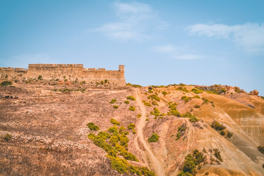
Start with a walk around Gozo’s Fort Chambray. This abandoned fortress has an intriguing appearance and you might find yourself searching for a way in through the ancient walls, overgrown with palm trees. Somewhat disappointingly, it’s not possible to enter.

It turns out that this 18th Century citadel has had a strained history of development, or rather non-development. From its inception, its purpose as a fortified town struggled to materialise and it seems the difficulties have continued in recent years.
A holiday complex was due to be built in the 1990s but in the end that also didn’t happen. It’s now in new hands and apartments are being constructed on the site. For now though, unless you’re staying at one of the residences inside, you’ll have to stick to enjoying a nosey around the outside grounds, palm trees and all.

After you’ve finished wandering around Fort Chambray, at the southwest side of the building head down the sandy path, to the coast below.
Here you can enjoy spending time at the beautiful and quiet beach of Xatt l-Aħmar. This area is home to a small camping area and some salt pans.
Continue further west along the coastline and you’ll find a set of steps into the sea and you might spot divers heading into the water at the Xatt l-Aħmar wreck dive site, where there are several submerged wrecks.
From here it’s a short hike to reach Mgarr ix-Xini Tower and beach. Stand Up Paddle Boards are available to rent from the beach and at €11 for an hour are a great way to spend an afternoon.

There’s no lesson, just jump right on and hope for the best. In my case, this resulted in quite a lot of unintentional travelling backward. My top tip, if you’re falling off, fall into the water rather than trying to fall onto the board, it will hurt a lot less.

Xlendi Tower And Sanap Cliffs To Victoria
Hike duration: 1 hour and 20 minutes
Distance: 6.3 km
Xlendi Beach is quick to reach via regular buses from Victoria. It makes a great starting point before hiking to experience the sunset views over Gozo’s Sanap cliffs.

Before you start the walk proper, get your legs warmed up by climbing the cliff-face stairs to the little cave at Xlendi Bay (in front of the ice cream kiosk and boat launch area).

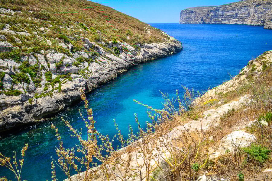
Once you’re back at the waterfront restaurants, walk over to the opposite side of the beach and follow the footpath around the bay to Xlendi Grotto.
This is a perfect place to take a dip in the enticing blue waters. You might even have the natural swimming pool all to yourself, as most holidaymakers stick to the bay in front of the restaurants in the main area of Xlendi. If you’re not keen on jumping in from the rocks, there’s a handy set of metal steps into the water partway down the rock face.

When you’ve finished floating around and basking on the rocks, take a walk over the stone bridge and head up the other side to take in a visit to Xlendi Tower and salt pans.

Walk back past Xlendi Tower and this time take the right-hand fork in the pathway, rather than taking the track back to the bridge, so you can pick up the coastal pathway. Here you can hike along the Gozo coast, following the pathway, until you reach the Sanap cliffs.

Red dots periodically mark the way on this route and if you make sure the coast is on your right you should be on the right track. Be aware that there are no railings so keep a safe distance from the cliff edge.

This is a great location to watch the sunset and the beautiful changing colours of the cliffs as the light fades. It’s one of the best Instagram spots on Gozo.
A concrete trail has been constructed for part of the coastline at Sanap, so you can pick this up and follow it until it turns left and inland.
From here, walk up the path until you reach a T-junction (with a wooden sign for Sanap cliffs) and turn right, where the path will quickly turn into a tarmac road.
Follow the road for approximately 700m, as you cross through the countryside. Eventually, you’ll reach Il-Munxar village and see a sign for Ix-Xlendi. Turn left onto Triq Ras Il Bajjada and at the end of the road, turn right then a quick left onto Dun Spir Gauci Santa. Walk past the Munxar church and keep going. Turn right at the end of the road, onto Triq Profs Guze Aquilina, then take the second left onto Triq Santa Dminka. This road will lead you up to Victoria.
Gozo Hiking – Western Route
Victoria To Dwejra And The Blue Hole

Hike duration: 2 hours
Distance: 9 km
This is one of the longer Gozo hiking routes but the reward for your hike is a swim in the mystical Blue Hole, at the site of the former Blue Window, one of Malta and Gozo’s best swimming spots.


Set off from the street called Dun Pawl Micallef, close to the Church of St Augustine, Victoria. Follow this street towards the quiet village of Kercem, passing by the Kercem Parish Church. At the end of the village, on Triq L Avukat Anton Calleja, the scenery opens out onto sweeping vistas of Gozo countryside.


From here, take Triq Qasam San Pawl and stay on this road all the way until you reach San Raflu Lake. The idea of an oasis amid the arid fields is an appealing prospect after hiking in the Gozo heat. However, it’s not a great place to sit, with murky water and plenty of flies for company. Instead, turn left here, towards the coast, and take the pathway to Gebel Ben Gorg.


Follow the coastline to the far southwest corner of Gozo and try to spot the Punic Temple (a cave-like structure carved into the rocks) as you turn the corner.
Next, it’s a short walk to reach the absolutely stunning views across Dwejra Bay. The circular shape and rock formation of this place is incredible. Grab amazing photos then get great Instagram Hiking Captions for Your Feed.

Take the rocky pathway to descend down into the bay. Here you have a choice, turn left at the tower and back towards Dwejra Bay and go for a swim there, or continue straight on to the Blue Hole for a dip. After the long hike to get here, why not spoil yourself and do both?

To get into the water at Dwejra Bay there is a set of quite well-hidden stone steps right at the rock edge, which you should be able to spot from your view opposite before you start the descent down to the sea.

Next, walk across to one of Gozo’s most famous sights, the location of the Blue Window (a natural rock arch that crashed into the sea in 2017) and the Blue Hole.
At the car park, there are kiosks to fill up on much-needed food and drink. Boat trips are available from the nearby Inland Sea but the best thing to do here is to scramble across the spikey rocks (water shoes required) and immerse yourself in the magical Blue Hole. This deep natural underwater space was formed over the years by the power of the sea and is a popular place for diving and snorkelling.
After such a long hike, you’ll be glad to know there’s a bus stop at the car park to take you up the very steep hill and back to Victoria and onto other places in Gozo. Make sure you check the time of the last bus though, you do not want to have to hike up that hill.
Find out what’s the best Blue Lagoon Malta Boat Trip.
Gozo Hiking – Eastern Route
Nadur To Hondoq Beach

Hike duration: 1 hour and 25 minutes
Distance: 6.3 km
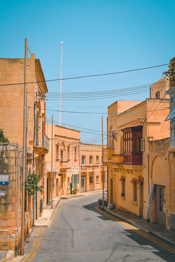
Nadur has a very traditional feel to it. All points seem to lead to the village square, which is overlooked by colourful balconies and the Parish Church. It’s here, in the heart of this typical Gozo village, that this fantastic walk starts. This hike is not for the faint-hearted, as it involves scrambling over some large rocks.

Before you set off, you might want to check out the little Maritime museum, at the corner of Parish Street and Triq Bernard Haber. It’s easy to spot by the large anchor outside (opening hours are very limited, mainly Thursdays and Saturdays).
Once you’re ready to leave Nadur, head away from the village on Il Knisja then left on to San Gwann. At the end of the road turn right on towards Qala and wander along the country road of Triq Il Qala. When you reach the roundabout, head straight over and continue on Triq Il Qala, then down Triq In Nadur.

On this road, you’ll pass Qala Parish Church and end up at a small village square with a few bars on it. Take a left onto Triq Il Kuncizzjoni and follow the road as it weaves its way through Gozo, with stunning views out across the land. Keep on this road as you pass a sign for Hondoq and the Blue Waters Dive shop.
When you reach the church of the Immaculate Conception of Our Lady, take the unmarked left turning immediately afterward (if not you’ll end up going directly to Honoq Beach without visiting St. Anthony’s Battery and a secret beach).
The concrete path winds to the right then keep a look out for the left turning, where it transforms into a cross-country track and twists and turns through the fields to take you all the way down to St Anthony’s Battery on the coast.

From the restored 18th Century military fortification, walk southwest and back along the cliffs towards Hondoq Bay.
After you pass the first inlet, you can scramble over the rocks, following the red dots and arrows, and head down to one of the best and most secluded beaches on Gozo. Glistening turquoise water laps at the brilliant white pebbles lining the shore. Once you’ve made it here, you may not want to leave.

If you can drag yourself away, rather than go back the way you came, continue on around the coast to Hondoq, where you can get food and catch the bus to Victoria (walk 15 minutes up Triq Il Kuncizzjoni, back past the Blue Waters Dive shop, and wait at the mini roundabout) or go further along the coast and finish the hike at Mgarr Harbour (buses leave regularly for Victoria from here).
Gozo Hiking – Northern Routes
Xaghra To Ramla Bay

Hike Duration: 30 minutes
Distance: 2 km
Although this is one of the shortest hiking routes in Gozo, it takes in both ancient ruins and Gozo’s longest sandy beach, Ramla Bay.
The starting point is my favourite place to stay on Gozo, Xaghra. The pretty village is home to the impressive Megalithic Ġgantija Temples. These ancient stones are some of the oldest freestanding monuments in the world.
Xaghra is one of the best places to stay in Gozo and Malta if you don’t have a car, especially if you want easy access to Ramla Bay, village restaurants and some of the island’s best walking routes. Find accommodation in Xaghra here.

Whilst you’re here, check out the windmill next door to the Temples to discover the vital role of grain in the 1919 revolt. Single or combined tickets, with the Temples, are available.

If you’re searching for something different to do in Xaghra, spend some time marvelling at the underground cave of Xerri’s Grotto, discovered under a residential property in the village on L Ghar Ta Xerri.

To head out on the hike, start at Xaghra Parish Church and walk along Triq It Tigrija until you turn left onto Triq Ghajn Qamar. Signs here will point you in the direction of Ramla and Calypso Cave. Keep on this road all the way away from the houses until you reach the cave.
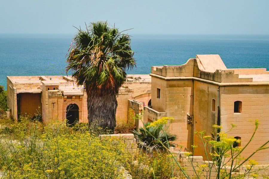
A little further on you’ll find a step descent to an abandoned mansion (Ulysses Lodge), where you can take in a stunning bird’s eye view of the red sands of Ramla Beach. Walk all the way down to the beach from here, following the rustic path.

Ramla has beach umbrellas, buckets and spades for sale and beachside cafes. The kiosks here are home to the best selection of ice creams on Gozo.
Spend a fun afternoon at the beach then make the short hike back to Xaghra. At night the village square chimes with the buzz of animated holiday conversations and the melodic local dialect. It’s a wonderful place to spend an evening.
If you enjoy hiking on Gozo, check out the hike at Monte Capanne, Elba, Italy. It’s another great European island hike.
Ta’ Pinu Sanctuary Via Wied il-Mielaħ To Marsalforn

Hike Duration: 2 hours
Distance: 9.5 km

If you’re up for a longer hike, walk from Ta’ Pinu Sanctuary in northwest Gozo to Marsalforn. To get to the start, take the bus (#308) from Victoria to Ta Pinu Sanctuary. Just past the church, turn left onto Triq ta’ Sdieri, then take the first right onto Triq Il-Blata. Follow the road all the way out to Wied il-Mielaħ.

The Wied il-Mielaħ arch seems to be becoming a replacement for Gozo’s Blue Window and is a stunning sight to see, particularly in the early evening.
On arrival at the site, there are steps down to get a closeup view of the incredible structure. It can get pretty windy on this part of the coast so hold on to your hats.

From Wied il-Mielaħ, follow the coast road eastwards all the way to the Star Wars-like rock formations, where the road turns inland to take you around the inlet of Wied il-Għasri.


Once you’ve passed the inlet, turn left and back out towards the coast. Take a detour and head down the steps to swim at Wied il-Għasri, it’s a beautiful location to enjoy a relaxing dip.

After a swim, climb back to the top and continue hiking the north Gozo coast eastwards until you reach Xwejni Beach. Here you can visit the salt pan formations and the Qolla I-Bajda Battery.


Walk for another 20 minutes and end the hike at busy Marsalforn, where regular buses will take you back to Victoria.
